


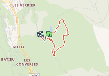
La Clusaz 2024 - Tour de chauffe

norbertmarteau
User

Length
3.3 km

Max alt
1575 m

Uphill gradient
180 m
Km-Effort
5.7 km

Min alt
1381 m

Downhill gradient
182 m
Boucle
Yes
Creation date :
2024-08-03 04:59:42.0
Updated on :
2024-08-03 04:59:43.4

FREE GPS app for hiking
 SityTrail
IGN / Geographical institutes
SityTrail Plus
The world is yours!
About
Trail of 3.3 km to be discovered at Auvergne-Rhône-Alpes, Upper Savoy, La Clusaz. This trail is proposed by norbertmarteau.
Positioning
Country:
France
Region :
Auvergne-Rhône-Alpes
Department/Province :
Upper Savoy
Municipality :
La Clusaz
Location:
Unknown
Start:(Dec)
Start:(UTM)
301176 ; 5085257 (32T) N.
Comments